Mount Gambier.
Mt Gambier was formed by volcano activity in the Pieistocene period- about 1 ½ million years ago. This and Mount Schank are the final phase of the volcanic activity in Australia.
The craters in them are formed by explosions called maars, the rim is made by ejected material laying on the Gambier limestone and drift sand. This area was a shallow inland sea and sand dunes.
We are here to get the washing machine fixed again and while that is happening we have made arrangements to have the recall on the car done, some bracket underneath.
We arrive on Sunday and are staying at the showgrounds and they have a trotting track. After getting van setup Larry goes and watches the trotting trials that are happening.
We can not drop off the machine until tomorrow and it is raining.
We end up having all week to see the sites so here they are.
Blue Lake
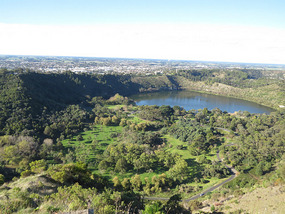
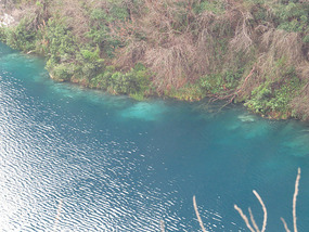
The water supply for Mt Gambier comes from the Blue Lake on the outskirts of town. This lake is called Blue lake because it is blue. In summer it is blue and in winter it is blue grey. This happens because dead algae ,which is yellow in colour, mixes with the top layer of water .; so the amount of light entering and coming out of the water is at its lowest.
The lake appears blue in summer as warmer water dissolves more calcite from limestone walls, this rises up and attaches to dead matter and other matter , gets heavy and sinks to the bottom, leaving clear water for the light to enter and shine blue.
The depth of the lake is 70metres.
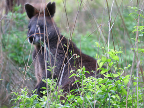
There is a park around the Blue Lake and some smaller lakes in town. All these lakes are in volcanic craters or sink holes. Part of park is fenced off as a nature reserve protecting all the native flora and fauna. We walk around it and it rains so most the birds and animals are hiding, we do see some kangaroos though. It a nice walk even in the rain about 2-3km .
Umpherston sink hole
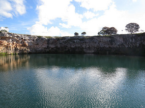
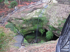
There are a few sink holes in and around town, these are when the ground has collapsed into a cave. The caves would have been formed after water seeping through the sandstone , making cracks and then eroding caves and after thousands of years these cracks weaken the roof of the cave and it collapse making a sink hole. Some sink holes have water in the bottom it depends on water table and the make up of the rock at the bottom.
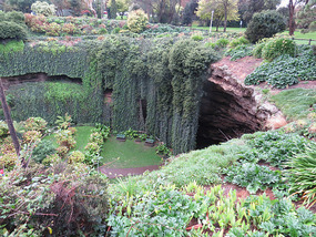
This sink hole is one of the ones in town. In 1884 James Umpherston built is homestead next to a sink hole and set about to create an escape from summer heat for his family by constructing walkways in the sink hole to the bottom and the water. He planted a garden of ferns , shrubs and trees all the way down ,on each level and a hut beside water. We walked down through the garden to the bottom but there was very little water , no hut. The land is now a park but the farmland part is now where the forest commission has part of its logging headquarters.
Telford scrub conservation park
This is out of town about 15km. And is 169 hectares providing refuge for native flora and fauna, including the rare southern brown bandicoot. There are koalas here too which where relocated from over populated parts of Kangaroo island. There is a short walk and a long walk, yes of course we do both and it is obvious that not many people walk the long walk. We are just walking along the sort of path and 2 foxes come running around the bend , both of them seem well fed and both were so surprised to see us they sped off in different directions. The ranger told us latter that bates were out for them.
Mount Schank
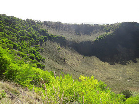
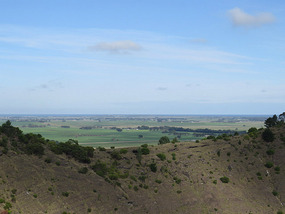
This cater has no water in the bottom of it as the floor is not lower than the surrounding land. The crater walls sit on the land and rise up 158 meters in places. This is an extinct volcano with evidence of of lava flow and changes in rock formation caused by heat and steam. We walk up to the lookout and around the crater rim, fantastic views of the area.
The walk up was very steep and after the lookout a bit unkept and narrow but well worth the struggle up and around.
Engelbecht cave
this is part of the lime stone caves under Mt. Gambier. It is filled with water and was discovered in 1884 and you have to be a qualified cave diver to go into it.
Some of the other caves you can have a tour of the drier parts but most have water in them.
Gail
this opened in 1866 and closed in 1995 and has now been made into accommodation .
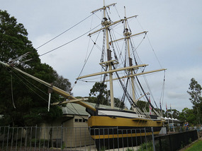
The information centre has a replica of the Lady Nelson sail boat out the front. HMS Lady Nelson was the first vessel to sail eastwood through Bass straight and in December 1800 land was sighted. The first mountain sited was Mt. Schank and named after Captain Schank, the second sighted was named after Lord Gambier. On this trip Cape Northumberland and Cape Banks where also named.
Penambol conservation park and Caroline Sinkhole.
We drove out towards the coast and the border for 15km through all these pine plantations to find this and spen the morning in the rain walking for 3 hours, yes we are getting bored and need to be moving on. Hopefully in the next couple of days we can resume our trek to the west.
If it was not the fact that our little machine is handy and still under warranty and was supposed to have been already fixed we would have got rid of it and gone on with our trip.
Just waiting around
Monday, June 02, 2014
 Mount Gambier, South Australia, Australia
Other Entries
-
20The Cassowary Coast
Oct 23222 days prior Tully, Australiaphoto_camera11videocam 0comment 0
 -
21More waterfalls and creeks
Oct 28217 days prior Ingham, Australiaphoto_camera20videocam 0comment 2
 -
22Time in Townsville
Nov 04210 days prior Townsville, Australiaphoto_camera15videocam 0comment 0
 -
23Heading across Queensland again
Nov 10204 days prior Ravenswood and Charters Towers, Australiaphoto_camera12videocam 0comment 2
 -
24Hot ,dry ,country
Nov 11203 days prior Hughenden, Australiaphoto_camera10videocam 0comment 1
 -
25Mining Town
Nov 19195 days prior Mount Isa, Australiaphoto_camera11videocam 0comment 1
 -
26Mount Isa to Birdsville
Nov 25189 days prior Birdsville, Australiaphoto_camera18videocam 0comment 0
 -
27Hot Dry Track
Dec 03181 days prior Birdsville Track, Australiaphoto_camera17videocam 0comment 0
 -
28Flinders ranges
Dec 09175 days prior Arkaroola, Australiaphoto_camera18videocam 0comment 1
 -
29SA to NSW
Dec 23161 days prior Broken Hill, Australiaphoto_camera16videocam 0comment 1
 -
30Riverina area
Jan 09144 days prior Wentworth, Australiaphoto_camera8videocam 0comment 1
 -
31Narrandera to Benalla
Jan 25128 days prior Narrandera, Australiaphoto_camera12videocam 0comment 2
 -
32North West Tasmania
Feb 20102 days prior Devonport Tasmania, Australiaphoto_camera18videocam 0comment 1
 -
33Heading to south Tasmania
Feb 2894 days prior Cradle mountain Tasmania, Australiaphoto_camera14videocam 0comment 1
 -
34East Coast Tasmania
Mar 1480 days prior St Helens, Australiaphoto_camera21videocam 0comment 1
 -
35Last ten Days Tasmania
Mar 2470 days prior Devonport, Australiaphoto_camera17videocam 0comment 0
 -
36On the move again -at last
May 285 days prior Warrnambool, Australiaphoto_camera15videocam 0comment 0
 -
37Just waiting around
Jun 02 Mount Gambier, Australiaphoto_camera11videocam 0comment 0
 -
38Coastal National Parks and quite
Jun 119 days later Beachport Limestone coast, Australiaphoto_camera11videocam 0comment 0
 -
39Murray Bridge to Whyalla
Jun 2018 days later Whyalla, Australiaphoto_camera15videocam 0comment 2
 -
40Eyre peninsular
Jun 3028 days later Port Lincoln To Ceduna, Australiaphoto_camera16videocam 0comment 1
 -
41Across the Nullarbor to WA
Jul 0735 days later Eucla WA, Australiaphoto_camera20videocam 0comment 1
 -
42The WA side of Nullarbor
Jul 1442 days later Hyden WA, Australiaphoto_camera20videocam 0comment 1
 -
434 months of surprises
Feb 07250 days later Benalla, Australiaphoto_camera11videocam 0comment 0
 -
44Are we on the move again
Feb 07250 days later Benalla, Australiaphoto_camera5videocam 0comment 0
 -
4510 days on Kangaroo island in Rooftop tent
Feb 07250 days later Kangaroo Island, Australiaphoto_camera12videocam 0comment 0
 -
46Jervis Bay to Ceduna
Feb 14257 days later Rapid Bay to Ceduna, Australiaphoto_camera13videocam 0comment 1
 -
47Ceduna and on west to Albany WA
Mar 07278 days later Albany, Australiaphoto_camera28videocam 0comment 0
 -
48To Bunbury and finally past Perth to Bindoon
Mar 21292 days later Bindoon, Australiaphoto_camera23videocam 0comment 0
 -
49Bindoon to Mullewa
Mar 29300 days later Mullewa, Australiaphoto_camera26videocam 0comment 0
 -
50Change of direction to get to same place
Apr 06308 days later Carnarvon, Australiaphoto_camera23videocam 0comment 1
 -
51Cape Range NP and Ningaloo Reef marine park
Apr 27329 days later Exmouth, Australiaphoto_camera24videocam 0comment 5
 -
52Gorge time
May 15347 days later Karijini National Park, Australiaphoto_camera31videocam 0comment 0
 -
53Karijini to Port Hedland
May 23355 days later Port Hedland, Australiaphoto_camera27videocam 0comment 0
 -
54Cape Keraudren. Broome .Derby
Jun 09372 days later Derby, Australiaphoto_camera24videocam 0comment 1
 -
55The Gibb river road.
Jul 12405 days later Derby, Australiaphoto_camera38videocam 0comment 0

 Mount Gambier, South Australia, Australia

2025-05-22